
Świętokrzyskie Voivodeship
Świętokrzyskie Voivodeship
Województwo świętokrzyskie | |
|---|---|
.svg) Location within Poland | |
 Division into counties | |
| Coordinates (Kielce): 50°53′N 20°37′E / 50.883°N 20.617°E | |
| Country | |
| Capital | Kielce |
| Counties | |
| Government | |
| • Body | Executive board |
| • Voivode | Józef Bryk (KO) |
| • Marshal | Renata Janik (OdNowa RP) |
| • EP | Lesser Poland and Świętokrzyskie |
| Area | |
| • Total | 11,672 km2 (4,507 sq mi) |
| Population (2019) | |
| • Total | 1,237,369 |
| • Density | 110/km2 (270/sq mi) |
| • Urban | 562,221 |
| • Rural | 675,148 |
| GDP | |
| • Total | €13.147 billion |
| • Per capita | €10,700 |
| ISO 3166 code | PL-26 |
| Vehicle registration | T |
| HDI (2019) | 0.866[2] very high · 12th |
| Website | https://www.kielce.uw.gov.pl/ |
| |


Świętokrzyskie Voivodeship (Polish: województwo świętokrzyskie [vɔjɛˈvut͡stfɔ ɕfjɛntɔˈkʂɨskʲɛ] ⓘ),[3] also known as Holy Cross Voivodeship, is a voivodeship (province) in southeastern Poland, in the historical region of Lesser Poland. The province's capital and largest city is Kielce.
Świętokrzyskie Voivodeship is bounded by six other voivodeships: Masovian to the north, Lublin to the east, Subcarpathian to the southeast, Lesser Poland to the south, Silesian to the southwest, and Łódź to the northwest.
Holy Cross Province was created on 1 January 1999 out of the former Kielce Voivodeship, eastern Częstochowa Voivodeship, and western Tarnobrzeg Voivodeship, pursuant to the Polish local government reforms adopted in 1998. The province covers an area of 11,672 square kilometres (4,507 sq mi), making it the second smallest province (after Opole). As at 2019, the total population of Świętokrzyskie Province was 1,237,369.
Cities and towns[edit]
_(jw14).JPG)

The voivodeship contains 4 cities and 39 towns. These are listed below in descending order of population (according to official figures for 2019[4]):
- Kielce (195,266)
- Ostrowiec Świętokrzyski (68,641)
- Starachowice (48,646)
- Skarżysko-Kamienna (45,068)
Towns:
- Sandomierz (23,494)
- Końskie (19,176)
- Busko-Zdrój (15,832)
- Jędrzejów (15,076)
- Staszów (14,762)
- Pińczów (10,774)
- Włoszczowa (9,985)
- Suchedniów (8,347)
- Połaniec (8,098)
- Opatów (6,466)
- Sędziszów (6,451)
- Stąporków (5,639)
- Kazimierza Wielka (5,550)
- Ożarów (4,569)
- Chęciny (4,444)
- Małogoszcz (3,748)
- Chmielnik (3,681)
- Radoszyce (3,135)
- Ćmielów (3,012)
- Kunów (2,967)
- Daleszyce (2,896)
- Wąchock (2,766)
- Koprzywnica (2,470)
- Bodzentyn (2,233)
- Osiek (2,007)
- Oleśnica (1,849)
- Zawichost (1,771)
- Morawica (1,711)
- Łagów (1,580)
- Stopnica (1,420)
- Nowa Słupia (1,360)
- Skalbmierz (1,285)
- Pierzchnica (1,144)
- Pacanów (1,108)
- Szydłów (1,097)
- Nowy Korczyn (942)
- Działoszyce (907)
- Wiślica (516)
- Opatowiec (332)
Administrative division[edit]
Świętokrzyskie Voivodeship is divided into 14 counties (powiats): 1 city county and 13 land counties. These are further divided into 102 gminas.
The counties are listed in the following table (ordering within categories is by decreasing population).
| English and Polish names |
Area (km2) |
Population (2019) |
Seat | Other towns | Total gminas |
| City counties | |||||
| Kielce | 110 | 195,266 | 1 | ||
| Land counties | |||||
| Kielce County powiat kielecki |
2,247 | 210,940 | Kielce * | Chęciny, Chmielnik, Daleszyce, Bodzentyn | 19 |
| Ostrowiec County powiat ostrowiecki |
616 | 109,512 | Ostrowiec Świętokrzyski | Ćmielów, Kunów | 6 |
| Starachowice County powiat starachowicki |
523 | 89,925 | Starachowice | Wąchock | 5 |
| Jędrzejów County powiat jędrzejowski |
1,257 | 85,757 | Jędrzejów | Sędziszów, Małogoszcz | 9 |
| Końskie County powiat konecki |
1,140 | 80,154 | Końskie | Stąporków, Radoszyce | 8 |
| Sandomierz County powiat sandomierski |
676 | 77,352 | Sandomierz | Koprzywnica, Zawichost | 9 |
| Skarżysko County powiat skarżyski |
395 | 74,343 | Skarżysko-Kamienna | Suchedniów | 5 |
| Staszów County powiat staszowski |
925 | 72,000 | Staszów | Połaniec, Osiek, Szydłów, Oleśnica | 8 |
| Busko County powiat buski |
967 | 71,807 | Busko-Zdrój | Pacanów, Nowy Korczyn | 8 |
| Opatów County powiat opatowski |
912 | 52,336 | Opatów | Ożarów | 8 |
| Włoszczowa County powiat włoszczowski |
906 | 45,137 | Włoszczowa | 6 | |
| Pińczów County powiat pińczowski |
611 | 39,100 | Pińczów | Działoszyce | 5 |
| Kazimierza County powiat kazimierski |
422 | 35,770 | Kazimierza Wielka | Skalbmierz | 5 |
| * seat not part of the county | |||||
Economy[edit]
The Gross domestic product (GDP) of the province was 11.6 billion € in 2018, accounting for 2.3% of the Polish economic output. GDP per capita adjusted for purchasing power was 15,400 € or 51% of the EU27 average in the same year. The GDP per employee was 58% of the EU average. Świętokrzyskie Voivodship is the province with the fifth lowest GDP per capita in Poland.[5]
Protected areas[edit]

Protected areas in Świętokrzyskie Voivodeship include one National Park and nine Landscape Parks. These are listed below.
- Świętokrzyski National Park
- Chęciny-Kielce Landscape Park
- Cisów-Orłowiny Landscape Park
- Jeleniowska Landscape Park
- Kozubów Landscape Park
- Nida Landscape Park
- Przedbórz Landscape Park (partly in Łódź Voivodeship)
- Sieradowice Landscape Park
- Suchedniów-Oblęgorek Landscape Park
- Szaniec Landscape Park
Sights and tourism[edit]

There are ten Historic Monuments of Poland and one World Heritage Site in the voivodeship:
- Krzemionki Prehistoric Striped Flint Mining Region (listed as both)
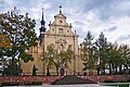
- Kraków Bishops Palace and Kielce Cathedral
- Henryk Sienkiewicz Palace with park in Oblęgorek
- St. Martin's Collegiate Church, Opatów
- Camaldolese monastery complex in Rytwiany
- Old Town of Sandomierz[6]
- Benedictine monastery complex at Święty Krzyż
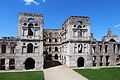
- Krzyżtopór Castle in Ujazd[7]
- Wąchock Abbey
- Collegiate Basilica of the Birth of the Blessed Virgin Mary and stronghold in Wiślica
Preserved small old towns include Opatów and the fortified town of Szydłów. There are multiple castles, including in Bodzentyn, Chęciny, Sandomierz and Szydłów, and palaces, including in Czyżów Szlachecki and Kurozwęki.
There are two spa towns: Busko-Zdrój and Solec-Zdrój.
-

-
-
 Town Hall in Sandomierz
 -
 Święty Krzyż Monastery
 -
-

-
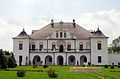 Czyżów Szlachecki Palace
 -
 Fortified town of Szydłów
 -
 Main square and town hall in Opatów
 -
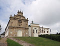
 Sanatorium Marconi in Busko-Zdrój


.jpg)
Sports[edit]
Handball and football enjoy the largest following in the province.
| Club | Sport | League | Trophies |
|---|---|---|---|
| Barlinek Industria Kielce | Handball (men's) | Superliga | 20 Polish Championships 17 Polish Cups 1 EHF Champions League (2016) |
| Korona Kielce | Football (men's) | Ekstraklasa | 0 |
| Korona Handball Kielce | Handball (women's) | Liga Centralna Kobiet | 0 |
See also[edit]
References[edit]
- ^ "EU regions by GDP, Eurostat". Retrieved 18 September 2023.
- ^ "Sub-national HDI - Subnational HDI - Global Data Lab". globaldatalab.org. Radboud University Nijmegen. Retrieved 13 December 2021.
- ^ "Contact". The Marshal Office of the Świętokrzyskie Voivodeship.
- ^ GUS. "Population. Size and structure and vital statistics in Poland by territorial division in 2019. As of 30th June". stat.gov.pl. Retrieved 11 September 2020.
- ^ "Regional GDP per capita ranged from 30% to 263% of the EU average in 2018". Eurostat.
- ^ Rozporządzenie Prezydenta Rzeczypospolitej Polskiej z dnia 22 listopada 2017 r. w sprawie uznania za pomnik historii "Sandomierz - historyczny zespół architektoniczno-krajobrazowy", Dz. U. z 2017 r. poz. 2273
- ^ Rozporządzenie Prezydenta Rzeczypospolitej Polskiej z dnia 20 kwietnia 2018 r. w sprawie uznania za pomnik historii "Ujazd - ruiny zamku Krzyżtopór", Dz. U. z 2018 r. poz. 943
External links[edit]
- Świętokrzyskie Voivodeship official website (Polish, English, German)
- Świętokrzyski Urząd Wojewódzki Official website (Polish, English, Russian, Ukrainian, French)
- Regional Tourist Information Center official website (Polish, English, German)
Places adjacent to Świętokrzyskie Voivodeship | |
|---|---|
| City counties |
|  |
|---|---|---|
| Land counties | ||
50°45′56″N 20°46′25″E / 50.76556°N 20.77361°E
| International | |
|---|---|
| National | |
| Geographic | |
| Other | |